
11 posts tagged with "New"

New features

View All Tags

Forecast alerts are now instant, too

LMKwhen Team
Product updates

Forecast-threshold rules — heat, humidity, wind, precipitation, tropical, and more — now evaluate the moment a location is created, imported, or moved, completing the instant-alert work from the last release. New locations no longer wait up to six hours for the next forecast cycle.

What is new

  • Instant forecast checks on change — creating, importing, moving, or re-enabling a location checks it against the latest forecast right away, alongside the watch, warning, advisory, and outlook checks that already ran instantly.
  • Moved locations re-checked immediately — move a location and it picks up the forecast for its new spot on the same change, not the next cycle.

Behind the scenes

Forecast storage moved to a shared weather-grid model: locations that fall on the same forecast grid cell now share one stored value instead of each keeping its own copy. That speeds up every forecast cycle and sets the stage for coverage beyond the lower 48.


There is nothing to turn on. Add or edit a location on the Locations page and its forecast rules take effect immediately.
Instant alerts for new and moved locations

LMKwhen Team
Product updates

Locations are now checked the moment you change them. Add a location, import a list, move a location on the map, or re-enable one during active weather, and it is matched against every active watch, warning, advisory, and outlook right away, instead of waiting for the next data cycle.

What is new

  • Instant evaluation on change — creating, importing, moving, or re-enabling a location evaluates it against all currently-active hazard polygons immediately. If it is already inside a warned area, the alert fires right away.
  • Move out, get an all-clear — moving a location out of a warned area sends an all-clear noting it is no longer in the warned area.
  • Move back in, the alert reopens — the original alert reopens with its history preserved, rather than starting a brand-new one.
  • No flapping — a location sitting near a warning edge is capped at one movement notification every 15 minutes per alert, so quick back-and-forth movement will not flood you.

One caveat

Forecast-threshold rules — like heat, wind, or snowfall — still evaluate on the next forecast update. Instant forecast checks are coming next.


There is nothing to turn on. Add or edit a location on the Locations page and it takes effect immediately.

A big batch of new forecast products to alert on

LMKwhen Team
Product updates

This release roughly doubles the forecast data you can build alert rules on — new heat, humidity, precipitation, winter, tropical, and fire-weather products, all usable from the rule wizard today.

Heat & humidity

  • Heat Stress (WBGT) — Wet Bulb Globe Temperature, the metric used for work/rest scheduling. Alert at or above the NIOSH reference points (82°F alert, 88°F exposure).
  • Max Humidity and Min Humidity — daily relative-humidity extremes. Min Humidity at or below 15% is a common Red Flag / fire-danger criterion.

Precipitation

  • Precip Probability (12-hour) — chance of measurable precipitation in a 12-hour window.
  • Total Precipitation — running 3-day accumulation through each forecast day.
  • Excessive Rainfall Outlook (WPC) — categorical flash-flood risk (Marginal → High) for Days 1–5. The single best advance signal for flash flooding, often days ahead of any Flash Flood Watch.

Winter

  • Winter Precip Probability (WPC) — the chance that snow or ice reaches a threshold:
    • Days 1–3: snow ≥ 4 in, ≥ 8 in, ≥ 12 in, and ice ≥ 0.25 in (Slight / Moderate / High probability bands)
    • Days 4–7: extended-range probability of ≥ 0.25 in of snow or sleet (10–90%)

Tropical

Populated whenever the National Hurricane Center has an active system affecting your locations:

  • Threat levels — hurricane Wind, Storm Surge, Flooding Rain, and Tornado threat (None → Extreme).
  • Wind probabilities — chance of tropical-storm-force (34 kt), 50 kt, and hurricane-force (64 kt) winds.

Fire weather

  • Dry Thunderstorm Outlook (SPC) — Isolated / Scattered dry-lightning risk, a leading cause of wildfire ignition, issued alongside the fire-weather outlooks.

To use any of these, open the Rules page, start a new rule, and choose the product under the forecast (NDFD) or outlook (SPC / WPC) rule types. Set your threshold and you're done — see the Forecast Products and WPC Outlooks guides for the full details.

An activity log for your account

LMKwhen Team
Product updates

When a teammate edits an alert rule, adds a location, or changes a delivery channel, you can now see it. Settings → Activity shows a running history of changes to your organization — locations added or removed, alert rules created or edited, delivery channels and contact methods changed, collection and tag updates, team member changes, and plan changes. Each entry tells you who made the change, when, and the specifics: which location (with its address and coordinates), which collection, what fields changed.

Automatic, system-driven changes are labeled too — so a plan downgrade that disabled some locations, or a carrier opt-out on a phone number, shows up clearly rather than silently. The activity log is available to organization owners and admins.

See exactly where the weather is — maps in your alerts

LMKwhen Team
Product updates

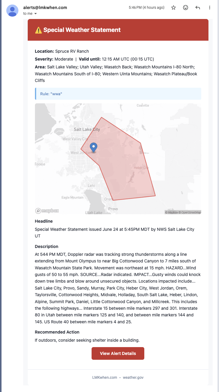
Every alert now comes with a map. Your email and Slack notifications show the hazard area — the warning polygon or the forecast outlook — with a pin on the exact property it affects, so you can tell at a glance whether the threat is right over your location or just nearby.

For Storm Prediction Center outlooks the map draws the full risk picture: each category — Marginal, Slight, Enhanced, and up — in its own color, with the band over your location highlighted, so a "Slight Risk" alert actually looks like the day's outlook instead of a single shape. And when you tap the link in a text message it now unfurls as a rich preview on your phone — the map and a one-line summary — before you even open it.

A severe weather alert email showing a map of the warning area with a pin on the affected property

Alert updates that tell you what changed

LMKwhen Team
Product updates

The National Weather Service revises an active warning constantly — a tornado threat goes from radar-indicated to observed, hail grows from 1" to 1.75", an expiration gets pushed back. Until now those revisions either passed silently or arrived as a repeat of the original alert. Now every update spells out exactly what changed: "Tornado threat now Observed; Hail 1.00" → 1.75"; Warning extended to 4:45 PM CDT." You'll see it on the alert page, in the history timeline and CSV export, and in the text, email, and Slack update itself.

To keep the signal clean, you control how often updates reach you, per rule: Escalations only (the default) notifies you when a warning gets more dangerous, All updates sends every change, and Off stays quiet until the all-clear. Times are shown in the warning's own local zone, and routine continuations that don't materially change anything no longer ping you at all.

Quiet hours with a morning digest

LMKwhen Team
Product updates

Not every alert needs to wake you up. With quiet hours, overnight notifications are held and rolled into a single digest delivered when your morning starts. The digest includes a shareable summary page, so you can forward what happened overnight to anyone — no login required. You can also choose to let critical warnings — like tornado, flash flood, and severe thunderstorm — break through quiet hours, so the alerts that matter most still reach you right away.

Weather alerts in Slack

LMKwhen Team
Product updates

You can now get LMKwhen alerts delivered straight to a Slack channel. Connect your workspace, pick a channel, and alerts arrive as rich messages with the location, hazard, and timing at a glance — and your team can acknowledge an alert without leaving Slack. It's the easiest way to put severe weather in front of the whole team at once. Set it up under Notification Channels in your settings.

Add your whole portfolio at once

LMKwhen Team
Product updates

Managing dozens or hundreds of properties? Upload a CSV and we'll add every address in one pass, ready to attach to alert rules immediately. What used to be an afternoon of data entry is now a single upload.

A guided way to build alert rules

LMKwhen Team
Product updates

Setting up the right alerts is now a guided, three-path process. Choose official watches and warnings, severe weather outlooks for advance planning, or forecast thresholds like temperature and wind — and the wizard walks you through which locations and channels each rule covers. You get precise alerting without needing to know how weather products work behind the scenes.